planisphere

Map depicting the Earth’s two hemispheres.
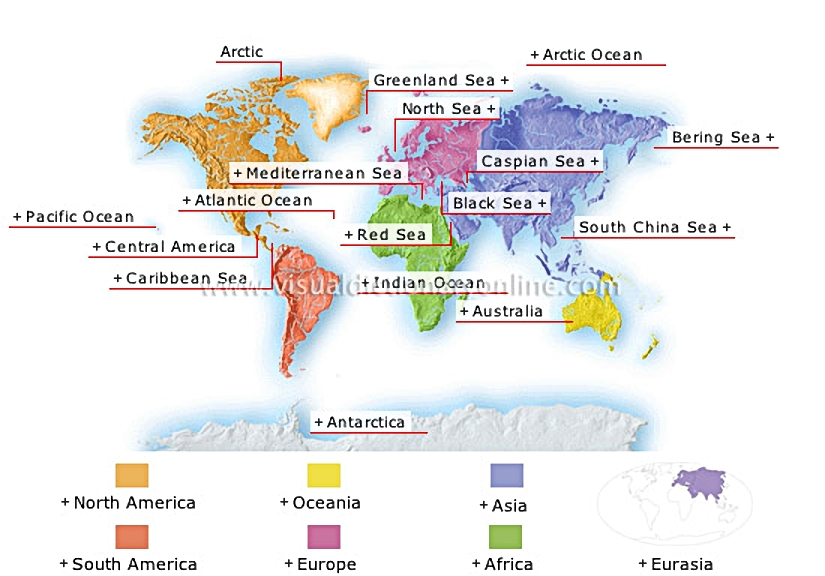
planisphere 						The world’s largest ocean (69 million mi2), the Pacific covers 30% of the Earth’s surface, more than all of the continents put together.												Extends from the Isthmus of Tehuantepec in Mexico to the Isthmus of Panama.												Body of water (1.1 million mi2) located between Central America and the northern portion of South America.												The world’s second largest ocean (36 million mi2); it covers 20% of the Earth’s surface.												The only uninhabited continent (5 million mi2), located inside the south polar circle; 98% of its surface is covered with an ice cap. Antarctica holds 90% of the Earth’s freshwater reserves.												Gulf (165,000 mi2) located between Africa and the Arabian Peninsula; it connects to the Mediterranean through the Suez Canal.												The world’s largest island (3 million mi2) is sparsely inhabited in spite of its size; because of its isolation, Australia’s wildlife is unique.												Relatively small ocean (29 million mi2) located between Africa, Asia and Australia; it has high water temperatures and is dotted with numerous islands.												The smallest of the oceans (5.8 million mi2), bordered by the northern coasts of Asia, America and Europe; it is largely covered with pack ice.												Southern part of the China Sea bordering the entire southeast coast of Asia as well as Borneo, the Philippines and Taiwan.												Northern part of the Pacific between Kamchatka (in Asia) and Alaska; it is deepest in its southern portion.												The world’s largest lake (140,000 mi2), located between Europe and Asia; it has no link to an ocean and is diminishing in size.												Inland sea (162,000 mi2) between Eastern Europe and Asia; it opens into the Mediterranean through two straits, the Dardanelles and the Bosporus.												One of the largest inland seas in the world (965,000 mi2); it lies between Europe, Africa and Asia and connects to the Atlantic Ocean through the Strait of Gibraltar.												Sea (465,000 mi2) in the North Atlantic; it is bordered by the coast of Greenland.												Relatively shallow sea (220,000 mi2) in the North Atlantic and bordered by the coasts of Europe; some major European ports are located along its estuaries.												Vast region inside the north polar circle; it includes the Arctic Ocean and the lands bordering it.				  							Composed of Europe and Asia, Eurasia represents about 39% of the world’s land; it forms a true continent that geographers have distinguished for historical and ethnographic reasons.												Continent that represents about 20% of the world’s land; two-thirds of its surface lies north of the Equator. Characterized by very hot climates, Mediterranean in the north and south, tropical and arid elsewhere.												The largest and most populous continent, Asia represents 32% of the world’s land; it is dominated by imposing mountain ranges.												Western extremity of the vast Eurasian continent that, by convention, is separated from Asia by the Ural Mountains; it covers a relatively small area.												Continent that represents 6% of the world’s land and features a great many islands in the Pacific and Indian oceans; Australia is its true continent.												Represents 12% of the world’s land;  linked to North America by Central America; it includes the Andes in the west and plains and plateaus in east and central regions.												Its area (9.3 million mi2) represents about 16% of the world’s land; the Central American isthmus is an extension of North America.
See Also


ocean floor

common coastal features

examples of shorelines

hydrologic cycle

ocean trenches and ridges

North America

Americas?[1]

Caribbean Islands

Antarctica

Africa

Oceania

Oceania and Polynesia

wave

Europe

Asia

South America

vegetation regions

tectonic plates

Pacific Ocean

The world’s largest ocean (69 million mi2), the Pacific covers 30% of the Earth’s surface, more than all of the continents put together.
ocean floor
ocean floor
common coastal features
examples of shorelines
hydrologic cycle
hydrologic cycle
ocean trenches and ridges

Central America

Extends from the Isthmus of Tehuantepec in Mexico to the Isthmus of Panama.
North America
North America
Americas [1]
Americas [1]

Caribbean Sea

Body of water (1.1 million mi2) located between Central America and the northern portion of South America.
North America
North America
examples of shorelines
common coastal features
Caribbean Islands
Caribbean Islands

Atlantic Ocean

The world’s second largest ocean (36 million mi2); it covers 20% of the Earth’s surface.
ocean trenches and ridges
hydrologic cycle
hydrologic cycle
examples of shorelines
common coastal features
ocean floor
ocean floor

Antarctica

The only uninhabited continent (5 million mi2), located inside the south polar circle; 98% of its surface is covered with an ice cap. Antarctica holds 90% of the Earth’s freshwater reserves.
Antarctica
Antarctica

Red Sea

Gulf (165,000 mi2) located between Africa and the Arabian Peninsula; it connects to the Mediterranean through the Suez Canal.
common coastal features
examples of shorelines
ocean trenches and ridges
Africa
Africa

Australia

The world’s largest island (3 million mi2) is sparsely inhabited in spite of its size; because of its isolation, Australia’s wildlife is unique.
Oceania
Oceania
Oceania and Polynesia

Indian Ocean

Relatively small ocean (29 million mi2) located between Africa, Asia and Australia; it has high water temperatures and is dotted with numerous islands.
ocean trenches and ridges
hydrologic cycle
hydrologic cycle
examples of shorelines
common coastal features
ocean floor
ocean floor

Arctic Ocean

The smallest of the oceans (5.8 million mi2), bordered by the northern coasts of Asia, America and Europe; it is largely covered with pack ice.
common coastal features
examples of shorelines
hydrologic cycle
hydrologic cycle
ocean trenches and ridges
ocean floor
ocean floor

South China Sea

Southern part of the China Sea bordering the entire southeast coast of Asia as well as Borneo, the Philippines and Taiwan.
common coastal features
examples of shorelines
ocean trenches and ridges

Bering Sea

Northern part of the Pacific between Kamchatka (in Asia) and Alaska; it is deepest in its southern portion.
common coastal features
examples of shorelines
ocean trenches and ridges

Caspian Sea

The world’s largest lake (140,000 mi2), located between Europe and Asia; it has no link to an ocean and is diminishing in size.
common coastal features
examples of shorelines

Black Sea

Inland sea (162,000 mi2) between Eastern Europe and Asia; it opens into the Mediterranean through two straits, the Dardanelles and the Bosporus.
wave
wave
common coastal features
examples of shorelines

Mediterranean Sea

One of the largest inland seas in the world (965,000 mi2); it lies between Europe, Africa and Asia and connects to the Atlantic Ocean through the Strait of Gibraltar.
common coastal features
examples of shorelines
ocean trenches and ridges

Greenland Sea

Sea (465,000 mi2) in the North Atlantic; it is bordered by the coast of Greenland.
common coastal features
examples of shorelines
ocean trenches and ridges

North Sea

Relatively shallow sea (220,000 mi2) in the North Atlantic and bordered by the coasts of Europe; some major European ports are located along its estuaries.
common coastal features
examples of shorelines
ocean trenches and ridges
Europe
Europe

Arctic

Vast region inside the north polar circle; it includes the Arctic Ocean and the lands bordering it.

Eurasia

Composed of Europe and Asia, Eurasia represents about 39% of the world’s land; it forms a true continent that geographers have distinguished for historical and ethnographic reasons.
Asia
Asia
Europe
Europe

Africa

Continent that represents about 20% of the world’s land; two-thirds of its surface lies north of the Equator. Characterized by very hot climates, Mediterranean in the north and south, tropical and arid elsewhere.
Africa
Africa

Asia

The largest and most populous continent, Asia represents 32% of the world’s land; it is dominated by imposing mountain ranges.
Asia
Asia

Europe

Western extremity of the vast Eurasian continent that, by convention, is separated from Asia by the Ural Mountains; it covers a relatively small area.
Europe
Europe

Oceania

Continent that represents 6% of the world’s land and features a great many islands in the Pacific and Indian oceans; Australia is its true continent.
Oceania and Polynesia
Oceania
Oceania

South America

Represents 12% of the world’s land; linked to North America by Central America; it includes the Andes in the west and plains and plateaus in east and central regions.
Americas [1]
Americas [1]
South America
South America

North America

Its area (9.3 million mi2) represents about 16% of the world’s land; the Central American isthmus is an extension of North America.
North America
North America
Americas [1]
Americas [1]