South America

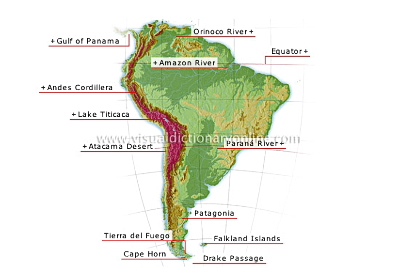
Linked to North America by Central America, its main features are the Andes Cordillera in the west and the plains and plateaus of the central and eastern regions.
South America 						Bounded in the north by the Isthmus of Panama, its coast is uneven and dotted with islands.												Longest mountain chain in the world (5,000 mi) and the second highest, it follows the western coast of South America; its highest peak is Aconcagua (22,834 feet).												Located in the Andes Cordillera between Peru and Bolivia; at an elevation of 12,500 feet, it is the highest navigable lake in the world.												Among the driest deserts on the planet, receiving only a few inches of rain per year.												Archipelago separated from the continent by the Magellan Strait; its cold damp climate results in perpetual snows from as low as 2,300 feet.				  							Southernmost point of South America, only 620 mi from Antarctica; famous for its storms and dangerous reefs and shoals.				  							Almost 560 mi wide, it separates Tierra del Fuego from Antarctica and connects the Atlantic to the Pacific; its currents are very powerful.				  							Archipelago composed of two main islands separated by the Falkland Strait, as well as some 100 islets.				  							Plateau in Chile and Argentina; it is divided into Andean Patagonia with a humid climate and abundant vegetation, and the Patagonian plateau, which is dry and sparse.				  							River (1,860 mi) with most of its course in Brazil; it marks the boundary between Brazil and Paraguay, and between Paraguay and Argentina.												Imaginary circle surrounding Earth at its widest circumference, dividing it into two hemispheres: the Northern hemisphere and the Southern hemisphere.												The largest river in the world in volume of flow; it rises in the Andes and flows for 4,090 mi through more than 80% of Brazil’s territory.												River in Venezuela (1,340 mi) that empties into the Atlantic through a vast delta; the volume of its flow is considerable.
See Also


ocean trenches and ridges

examples of shorelines

common coastal features

mountain

lake

desert

watercourse

hemispheres

grid system

Earth coordinate system

planisphere

Americas?[1]

Gulf of Panama

Bounded in the north by the Isthmus of Panama, its coast is uneven and dotted with islands.
ocean trenches and ridges
examples of shorelines
common coastal features

Andes Cordillera

Longest mountain chain in the world (5,000 mi) and the second highest, it follows the western coast of South America; its highest peak is Aconcagua (22,834 feet).
mountain
mountain

Lake Titicaca

Located in the Andes Cordillera between Peru and Bolivia; at an elevation of 12,500 feet, it is the highest navigable lake in the world.
common coastal features
examples of shorelines
lake
lake

Atacama Desert

Among the driest deserts on the planet, receiving only a few inches of rain per year.
desert
desert

Tierra del Fuego

Archipelago separated from the continent by the Magellan Strait; its cold damp climate results in perpetual snows from as low as 2,300 feet.

Cape Horn

Southernmost point of South America, only 620 mi from Antarctica; famous for its storms and dangerous reefs and shoals.

Drake Passage

Almost 560 mi wide, it separates Tierra del Fuego from Antarctica and connects the Atlantic to the Pacific; its currents are very powerful.

Falkland Islands

Archipelago composed of two main islands separated by the Falkland Strait, as well as some 100 islets.

Patagonia

Plateau in Chile and Argentina; it is divided into Andean Patagonia with a humid climate and abundant vegetation, and the Patagonian plateau, which is dry and sparse.

ParanĂ¡ River

River (1,860 mi) with most of its course in Brazil; it marks the boundary between Brazil and Paraguay, and between Paraguay and Argentina.
watercourse
watercourse

Equator

Imaginary circle surrounding Earth at its widest circumference, dividing it into two hemispheres: the Northern hemisphere and the Southern hemisphere.
hemispheres
hemispheres
grid system
grid system
Earth coordinate system

Amazon River

The largest river in the world in volume of flow; it rises in the Andes and flows for 4,090 mi through more than 80% of Brazil’s territory.
watercourse
watercourse

Orinoco River

River in Venezuela (1,340 mi) that empties into the Atlantic through a vast delta; the volume of its flow is considerable.
watercourse
watercourse