North America

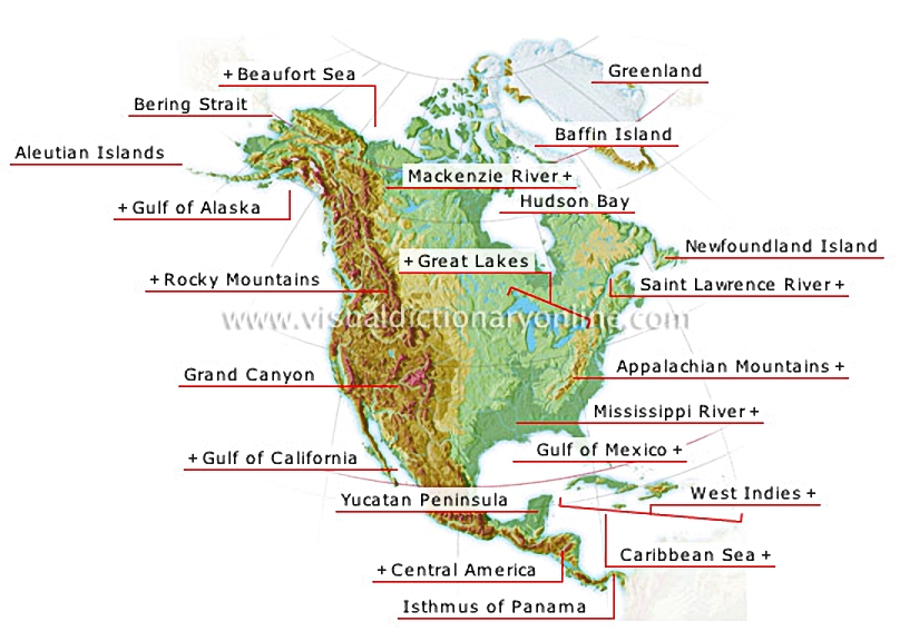
The Appalachians constitute the principal relief on the eastern part of the continent, while in the west, high mountain chains (the Rocky Mountains and the Sierra Madre) follow the coast from Alaska to Mexico.
North America 						The longest gorge in the world (220 mi); the Colorado River flows through it.				  							Separates the Baja California peninsula from the continent.												Part of the Atlantic located between the U.S., Mexico and Cuba.												Vast plateau characterized by aridity in the northwest and abundant precipitation in the south, where a dense forest grows.				  							Extends from the Isthmus of Tehuantepec in Mexico to the Isthmus of Panama.												Cut by a canal with locks that is 50 mi long. The Panama Canal opened in 1914 allowing maritime traffic to travel between the Caribbean Sea and the Pacific Ocean.				  							Body of water (1.1 million mi2) located between Central America and the northern portion of South America.												Archipelago that includes more than 700 islands, including the Greater Antilles in the north (Cuba, Haiti, Jamaica, Puerto Rico) and the Lesser Antilles in the east.												The Mississippi (2,350 mi) drainage basin covers the entire area between the Rocky Mountains and the Appalachians.												Old massif extending over 1,200 mi from the Canadian border to Alabama; its highest peak is Mount Mitchell (6,684 feet).												River (over 680 mi) that drains southeastern Canada and empties into the Atlantic Ocean.										  							These five lakes constitute the world’s largest reserve of fresh surface water (95,000 mi2).												Archipelago that is an extension of Alaska; it is composed of 150 islands and islets stretching over more than 1,000 mi.				  							Northeast part of the Pacific Ocean, bordering Alaska.												Second largest island in the world (over 770,000 mi2) after Australia.				  							Island in the Arctic Archipelago; the Baffin Sea separates it from Greenland.				  							Vast gulf that opens onto the Atlantic Ocean through the Hudson Strait; the bay is frozen seven months a year.				  							Canada’s longest river (2,635 mi).												Part of the Arctic Ocean between Alaska and the Arctic Archipelago.												Some 62 mi wide, it connects the Pacific Ocean to the Arctic Ocean.				  							Eastern margin of the western cordilleras, extending from Alaska to Mexico.

See Also


ocean trenches and ridges

examples of shorelines

common coastal features

Americas?[1]

Caribbean Islands

watercourse

mountain

lake

Grand Canyon

The longest gorge in the world (220 mi); the Colorado River flows through it.

Gulf of California

Separates the Baja California peninsula from the continent.
ocean trenches and ridges
examples of shorelines
common coastal features

Gulf of Mexico

Part of the Atlantic located between the U.S., Mexico and Cuba.
ocean trenches and ridges
examples of shorelines
common coastal features

Yucatan Peninsula

Vast plateau characterized by aridity in the northwest and abundant precipitation in the south, where a dense forest grows.

Central America

Extends from the Isthmus of Tehuantepec in Mexico to the Isthmus of Panama.
Americas [1]
Americas [1]

Isthmus of Panama

Cut by a canal with locks that is 50 mi long. The Panama Canal opened in 1914 allowing maritime traffic to travel between the Caribbean Sea and the Pacific Ocean.

Caribbean Sea

Body of water (1.1 million mi2) located between Central America and the northern portion of South America.
common coastal features
examples of shorelines
Caribbean Islands
Caribbean Islands

West Indies

Archipelago that includes more than 700 islands, including the Greater Antilles in the north (Cuba, Haiti, Jamaica, Puerto Rico) and the Lesser Antilles in the east.
Caribbean Islands
Caribbean Islands

Mississippi River

The Mississippi (2,350 mi) drainage basin covers the entire area between the Rocky Mountains and the Appalachians.
watercourse
watercourse

Appalachian Mountains

Old massif extending over 1,200 mi from the Canadian border to Alabama; its highest peak is Mount Mitchell (6,684 feet).
mountain
mountain

Saint Lawrence River

River (over 680 mi) that drains southeastern Canada and empties into the Atlantic Ocean.
watercourse
watercourse

Newfoundland Island

Great Lakes

These five lakes constitute the world’s largest reserve of fresh surface water (95,000 mi2).
lake
lake
examples of shorelines
common coastal features

Aleutian Islands

Archipelago that is an extension of Alaska; it is composed of 150 islands and islets stretching over more than 1,000 mi.

Gulf of Alaska

Northeast part of the Pacific Ocean, bordering Alaska.
ocean trenches and ridges
examples of shorelines
common coastal features

Greenland

Second largest island in the world (over 770,000 mi2) after Australia.

Baffin Island

Island in the Arctic Archipelago; the Baffin Sea separates it from Greenland.

Hudson Bay

Vast gulf that opens onto the Atlantic Ocean through the Hudson Strait; the bay is frozen seven months a year.

Mackenzie River

Canada’s longest river (2,635 mi).
watercourse
watercourse

Beaufort Sea

Part of the Arctic Ocean between Alaska and the Arctic Archipelago.
common coastal features
examples of shorelines
ocean trenches and ridges

Bering Strait

Some 62 mi wide, it connects the Pacific Ocean to the Arctic Ocean.

Rocky Mountains

Eastern margin of the western cordilleras, extending from Alaska to Mexico.
mountain
mountain