ocean floor

Part of the Earth’s surface beneath the seas and the oceans; its topography is highly variable.
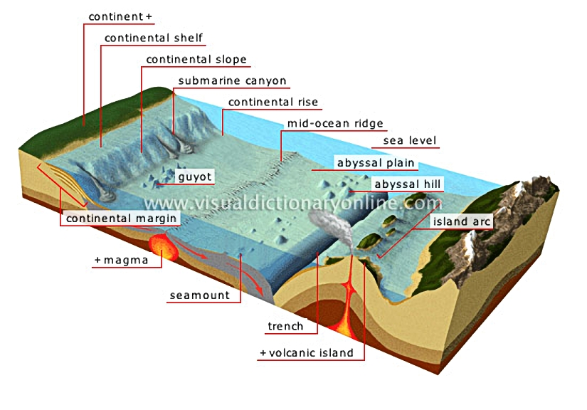
ocean floor 						Underwater extension of the continent; it comprises the continental shelf, the continental slope and the continental rise.				  							Section of the continental margin extending from the coast of the continent to the continental rise; its depth is no more than 660 feet.				  							Ancient volcano whose summit has been cut off by erosion and then submerged.				  							Molten rock and gas under very high pressure that can reach extremely high temperatures.												Isolated mountain of volcanic origin featuring a pointed summit.				  							Extremely deep elongated depression bordering a continent or island arc; it occurs when one tectonic plate moves under another.				  							Volcano whose summit rises above sea level.				  							String of volcanic islands formed when two tectonic plates meet.				  							Rounded underwater rise of low elevation.				  							Mean water level observed for a given duration (day, month, year); it is used as a reference to define coastal features and calculate the elevation of topographical elements.				  							Group of underwater mountain chains criss-crossing the oceans; it is formed by an outpouring of magma.				  							A collective term for the vast landmasses and their submerged margins.				  							Deep valley that is frequently the extension of a river; it ends in a sediment buildup.				  							Slope of a few degrees that extends from the continental shelf; it is 660 to 6,600 feet deep.				  							Gently sloping section of the continental margin; it connects the continental slope to the abyssal plain.				  							Zone located at a depth of 6,600 to 20,000 feet; it covers most of the ocean floor.
See Also


section of the Earths crust

structure of the Earth

ocean trenches and ridges

continental margin

Underwater extension of the continent; it comprises the continental shelf, the continental slope and the continental rise.

continental shelf

Section of the continental margin extending from the coast of the continent to the continental rise; its depth is no more than 660 feet.

guyot

Ancient volcano whose summit has been cut off by erosion and then submerged.

magma

Molten rock and gas under very high pressure that can reach extremely high temperatures.
section of the Earth’s crust
structure of the Earth

seamount

Isolated mountain of volcanic origin featuring a pointed summit.

trench

Extremely deep elongated depression bordering a continent or island arc; it occurs when one tectonic plate moves under another.

volcanic island

Volcano whose summit rises above sea level.

island arc

String of volcanic islands formed when two tectonic plates meet.

abyssal hill

Rounded underwater rise of low elevation.

sea level

Mean water level observed for a given duration (day, month, year); it is used as a reference to define coastal features and calculate the elevation of topographical elements.

mid-ocean ridge

Group of underwater mountain chains criss-crossing the oceans; it is formed by an outpouring of magma.

continent

A collective term for the vast landmasses and their submerged margins.

submarine canyon

Deep valley that is frequently the extension of a river; it ends in a sediment buildup.

continental slope

Slope of a few degrees that extends from the continental shelf; it is 660 to 6,600 feet deep.

continental rise

Gently sloping section of the continental margin; it connects the continental slope to the abyssal plain.

abyssal plain

Zone located at a depth of 6,600 to 20,000 feet; it covers most of the ocean floor.