station model

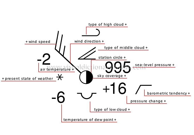
Method of representing information collected by an observation station on a weather map using symbols and numbers.
station model 						Sensation of heat or cold (°F) measured using an open-air thermometer shielded from direct sunlight.												Wind direction is indicated by the position of the wind shaft.												Type of precipitation (present weather) noted at the moment of observation.												Temperature (°F) at which water vapor in the air begins to condense; it is used to calculate humidity in the air.												Type of cloud observed between ground level and an altitude of 6,500 feet.												Positive or negative value that corresponds to the difference between the pressure reading and sea-level pressure; it is expressed in inches of mercury.												Variation in atmospheric pressure during the three hours preceding observation.												Proportion of the sky covered with cloud.												Reference pressure that corresponds to the pressure observed at sea level; it is expressed in inches of mercury.												Circle on a weather map that represents an observation station; displayed around the circle is the information collected by the station.												Type of cloud observed at altitudes between 6,500 and 20,000 feet.												Type of cloud observed at altitudes higher than 20,000 feet.												Wind speed is indicated by barbs and pennants whose values must be added.
See Also


measure of temperature

wind vane

wind

present weather?[1]

dew

low clouds

clouds

measure of air pressure

sky coverage

clouds?[1]

meteorological station

middle clouds

high clouds

anemometer

weather map

air temperature

Sensation of heat or cold (°F) measured using an open-air thermometer shielded from direct sunlight.
measure of temperature

wind direction

Wind direction is indicated by the position of the wind shaft.
wind vane
wind vane
wind
wind

present state of weather

Type of precipitation (present weather) noted at the moment of observation.
present weather [1]
present weather [1]

temperature of dew point

Temperature (°F) at which water vapor in the air begins to condense; it is used to calculate humidity in the air.
dew
dew
measure of temperature

type of low cloud

Type of cloud observed between ground level and an altitude of 6,500 feet.
low clouds
low clouds
clouds
clouds

pressure change

Positive or negative value that corresponds to the difference between the pressure reading and sea-level pressure; it is expressed in inches of mercury.
measure of air pressure

barometric tendency

Variation in atmospheric pressure during the three hours preceding observation.
measure of air pressure

sky coverage

Proportion of the sky covered with cloud.
sky coverage
sky coverage
clouds [1]
clouds [1]

sea-level pressure

Reference pressure that corresponds to the pressure observed at sea level; it is expressed in inches of mercury.
measure of air pressure

station circle

Circle on a weather map that represents an observation station; displayed around the circle is the information collected by the station.
meteorological station

type of middle cloud

Type of cloud observed at altitudes between 6,500 and 20,000 feet.
clouds
clouds
middle clouds
middle clouds

type of high cloud

Type of cloud observed at altitudes higher than 20,000 feet.
high clouds
high clouds
clouds
clouds

wind speed

Wind speed is indicated by barbs and pennants whose values must be added.
anemometer
anemometer
wind
wind